Engineering Surveying
Engineering surveying services in Geelong, Melbourne, Ballarat, regional Victoria and Colac
Swanson Surveying’s engineering surveyors in Geelong, Melbourne, Colac, and Ballarat are highly experienced and well supported by office staff, delivering a wide range of construction project requirements. Our team works closely with builders, engineers and architects to ensure high-quality data acquisition, QA analysis, preparation and site set out for projects of all sizes.
We offer a variety of engineering surveying services tailored to meet the demands of building, civil construction and larger infrastructure projects. As infrastructure projects grow in scale and complexity, our engineering surveyors often utilise industry-leading 3D software and technology including laser scanning and BIM 3D models for set out, exceeding client expectations.
Our services include dilapidation reports and monitoring surveys, where we capture existing conditions and monitor structures or ground marks to assess movement caused by construction works or land shifts. We provide construction set-out of gridlines, structures and levels so that new structures are spatially correct and properly documented.
We even offer as-built surveys in specific data formats including red line markups, Cad drafting, A Spec, point clouds or BIM models throughout any construction process, to ensure compliance is achieved and construction is meeting the specifications set out by the architect or design engineer.
Whether you need full time projects surveyors, initial site setup or data processing for your own survey technicians to use onsite, the Swanson Surveying team has the experience and technology to meet your requirements. Contact our friendly team for further details.
We also offer asset recording and civil construction surveying services.

Engineering Surveying – Barwon Health Women and Children’s Hospital
The Victorian Government has committed more than $500 million to deliver new and expanded women’s...
Read more
Engineering Surveying – Nyaal Banyul Geelong Convention and Event Centre
The Nyaal Banyul Geelong Convention and Event Centre precinct is the centrepiece project of the...
Read more
Engineering Surveying – South Geelong to Waurn Ponds Rail Upgrade
Swanson Surveying are currently completing engineering construction surveying for the South Geelong to Waurn Ponds...
Read more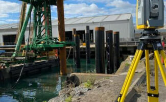
Engineering Surveying – Spirit of Tasmania Terminal Project, Geelong Port
Swanson Surveying have recently been engaged to provide engineering & civil surveying services to the...
Read more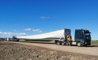
Land Surveying – Renewable Energy Sector, Berrybank Windfarm Stage 2
Swanson Surveying have recently been engaged to provide engineering & civil surveying services to Stage...
Read more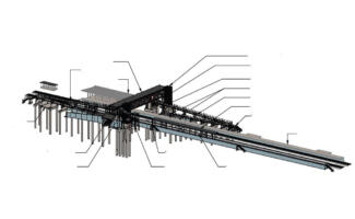
Engineering Surveying – Warrnambool Line Upgrade, Rail Projects Victoria
Swanson Surveying have recently completed works for a number of subcontractors to provide engineering and...
Read more
Construction Surveying – Point Wilson Waterside Infrastructure Upgrade Project, Geelong
Swanson Surveying have recently been engaged to provide engineering surveying services to the Point Wilson...
Read more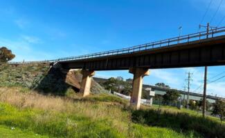
Engineering Surveying – Railway Bridge, Sunshine, Melbourne
The team at Swanson Surveying have recently undertaken an as-constructed survey along an Australian Rail...
Read more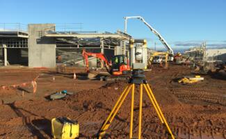
Land Surveyor – Opalia Shopping Centre, Melton
Swanson Surveying is currently undertaking a large land surveying project for the construction of the Opalia Shopping...
Read more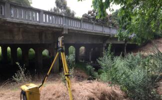
Land Surveying – Barongarook Bridge Replacement Project, Colac
Swanson Surveying was recently engaged to provide land surveying services for the replacement of the Barongarook Creek...
Read more
O-SPEC Surveys – Melbourne
Swanson Surveying has recently completed and had approved by the responsible authorities, as-built surveys of Public...
Read more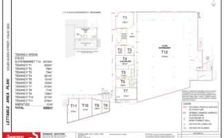
Engineering Surveying – Plaza Shopping Centre, Colac
Swanson Surveying has recently completed survey work on the development of the new Coles Supermarket...
Read more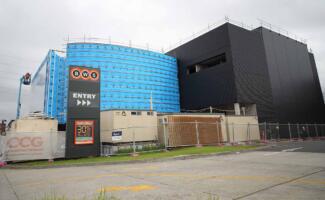
Engineering Surveying – Porsche Sales Centre, Melbourne
Swanson Surveying positioned the Porsche Sales Centre building in Collingwood relative to title boundaries, established...
Read more
Engineering Surveying – St Mary’s Terrace, Geelong
Swanson Surveying is currently undertaking surveying for the St Mary’s Terrace mixed-use development in Geelong, which...
Read more