Land Surveying
Comprehensive land surveying solutions for Geelong, Ballarat, Melbourne, regional Victoria and Colac
At Swanson Surveying, we provide a diverse range of land surveying services to clients across Geelong, Ballarat, Melbourne and regional Victoria. In addition to our expertise in land development and subdivision, civil and engineering surveying, asset recording, and advanced technologies such as laser scanning and UAV/drone surveys, we offer a wide variety of other land surveying services tailored to meet your specific project needs.
Below is a list and description of many of the common land surveying projects we undertake throughout Geelong, Ballarat, Melbourne, and regional Victoria:
Title re-establishment surveys
- We compute and mark the position of title boundaries relative to fences and other site features, ensuring your property boundaries are clear and accurate.
Feature and level surveys
- These surveys map land features and levels across a site, providing essential data for planning and design processes for land development and construction.
Site analysis and ResCode surveys
- Used for town planning and building design, these surveys assess the project site and adjacent properties to ensure compliance with planning regulations.
Deformation monitoring surveys
- We monitor marks on buildings or land to assess movement due to earthworks or natural land shifts, ensuring structural integrity.
Monitoring well surveys
- Accurate surveying of monitoring wells and bore holes for environmental assessments and reporting.
Volume surveys
- We assess stockpiles and excavations, providing precise measurements of volumes to support construction and earthworks projects, as well as end of year financial auditing requirements.
Australian Height Datum (AHD) level surveys
- Our AHD level surveys provide certified benchmarks to ensure accurate construction levels, certified by a licensed land surveyor.
Dilapidation surveys
- Document existing site conditions pre- and post-construction to record any changes or damage, ensuring comprehensive project documentation.
Cadastral survey plans
- Plans of consolidation: Consolidation of multiple land parcels into a single lot.
- Lease plans: For commercial properties such as shopping centres and service authorities such as Powercor, prepared in accordance with the Property Council of Australia guidelines (GLA, GLAR, NLA) or the Transfer of Land Act 1958.
- Road closures and deviations: Managing road deviations, exchanges, and discontinuances under the Local Government Act 1989 and Land Act 1958.
- Easement and restrictive covenants: Plans creating, varying, or removing easements and restrictive covenants as per the Subdivision Act 1988 and Transfer of Land Act 1958.
- Application surveys: Amending titles under the Transfer of Land Act 1958 for projects involving general law land, adverse possession, or boundary adjustments.
If your project requires professional land surveying in Geelong, Ballarat, Melbourne, regional Victoria or Colac, contact Swanson Surveying to discuss your needs or to arrange a free quote.

Coastal Cliff Land Survey – Allansford
Swanson Surveying was recently contracted to provide a feature and level survey of a future...
Read more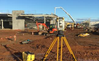
Land Surveyor – Opalia Shopping Centre, Melton
Swanson Surveying is currently undertaking a large land surveying project for the construction of the Opalia Shopping...
Read more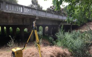
Land Surveying – Barongarook Bridge Replacement Project, Colac
Swanson Surveying was recently engaged to provide land surveying services for the replacement of the Barongarook Creek...
Read more
Land Surveyor – The Precinct Stage 2, Geelong
Swanson Surveying was recently awarded the contract as the consulting land surveyor for Stage 2...
Read more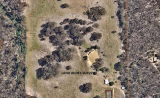
Title Re-Establishment Survey – Mount Franklin, Ballarat
The Swanson Surveying Ballarat Office was recently engaged to undertake a survey to re-establish and...
Read more
Land Surveyor – Rural Dams, Mornington Peninsula
Knowing a dam’s water carrying capacity is crucial for the agriculture industry which is why...
Read more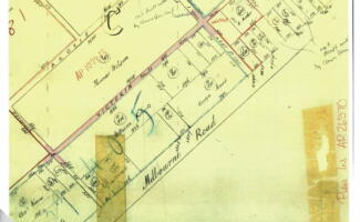
Adverse Possession Application – Rural Property, Little River
Recently the team at Swanson Surveying were engaged to undertake a survey of a rural...
Read moreTitle Re-Establishment Surveys – Sneydes Rd, Point Cook
Swanson Surveying has recently been engaged to undertake the title re-establishment surveys and construction set...
Read more